

Area 51: Difference between revisions
EnWikiAdmin (talk | contribs) No edit summary |
EnWikiAdmin (talk | contribs) No edit summary |
||
| Line 17: | Line 17: | ||
| nearest_town = [[Rachel, Lincoln County, Nevada]] | | nearest_town = [[Rachel, Lincoln County, Nevada]] | ||
| country = United States | | country = United States | ||
| image | | image = [[:File:Sentinel-Homey.png|A satellite image taken in 2022 captured by Sentinel-2 of ESA showing the base with Groom Lake just to the north-northeast]] | ||
| alt = A satellite image taken in 2022 captured by Sentinel-2 of ESA showing the base with Groom Lake just to the north-northeast | | alt = A satellite image taken in 2022 captured by Sentinel-2 of ESA showing the base with Groom Lake just to the north-northeast | ||
| caption = A [[satellite image]] taken in 2022 captured by [[Sentinel-2]] of [[ESA]] showing the base with Groom Lake just to the north-northeast | | caption = A [[satellite image]] taken in 2022 captured by [[Sentinel-2]] of [[ESA]] showing the base with Groom Lake just to the north-northeast | ||
| Line 104: | Line 104: | ||
==Geography== | ==Geography== | ||
===Area 51=== | ===Area 51=== | ||
[[File:Area51 Tikaboo Peak 07.2008.jpg|thumb|Area 51 viewed from distant [[Tikaboo Peak]]]] | [[:File:Area51 Tikaboo Peak 07.2008.jpg|thumb|Area 51 viewed from distant [[Tikaboo Peak]]]] | ||
The original rectangular base of {{convert|6|by|10|mi|km|0}} is now part of the so-called "Groom box", a rectangular area, measuring {{convert|23|by|25|mi|km}}, of restricted airspace. The area is connected to the internal [[Nevada Test Site]] (NTS) road network, with paved roads leading south to [[Mercury, Nevada|Mercury]] and west to [[Yucca Flat]]. Leading northeast from the lake, the wide and well-maintained Groom Lake Road runs through a pass in the Jumbled Hills. The road formerly led to mines in the Groom basin but has been improved since their closure. Its winding course runs past a security checkpoint, but the restricted area around the base extends farther east. After leaving the restricted area, Groom Lake Road descends eastward to the floor of the [[Tikaboo Valley]], passing the dirt-road entrances to several small ranches, before converging with [[Nevada State Route 375|State Route 375, the "Extraterrestrial Highway"]], south of [[Rachel, Nevada|Rachel]].<ref>{{cite news |url=http://travel.nytimes.com/2007/04/13/travel/escapes/13extraterrestrial.html |title=Lonesome Highway to Another World? |access-date=8 July 2007 |author=Regenold, Stephen |date=13 April 2007 |newspaper=The New York Times |archive-url=https://web.archive.org/web/20070617100409/http://travel.nytimes.com/2007/04/13/travel/escapes/13extraterrestrial.html |archive-date=17 June 2007 |url-status=live}}</ref> | The original rectangular base of {{convert|6|by|10|mi|km|0}} is now part of the so-called "Groom box", a rectangular area, measuring {{convert|23|by|25|mi|km}}, of restricted airspace. The area is connected to the internal [[Nevada Test Site]] (NTS) road network, with paved roads leading south to [[Mercury, Nevada|Mercury]] and west to [[Yucca Flat]]. Leading northeast from the lake, the wide and well-maintained Groom Lake Road runs through a pass in the Jumbled Hills. The road formerly led to mines in the Groom basin but has been improved since their closure. Its winding course runs past a security checkpoint, but the restricted area around the base extends farther east. After leaving the restricted area, Groom Lake Road descends eastward to the floor of the [[Tikaboo Valley]], passing the dirt-road entrances to several small ranches, before converging with [[Nevada State Route 375|State Route 375, the "Extraterrestrial Highway"]], south of [[Rachel, Nevada|Rachel]].<ref>{{cite news |url=http://travel.nytimes.com/2007/04/13/travel/escapes/13extraterrestrial.html |title=Lonesome Highway to Another World? |access-date=8 July 2007 |author=Regenold, Stephen |date=13 April 2007 |newspaper=The New York Times |archive-url=https://web.archive.org/web/20070617100409/http://travel.nytimes.com/2007/04/13/travel/escapes/13extraterrestrial.html |archive-date=17 June 2007 |url-status=live}}</ref> | ||
| Line 117: | Line 117: | ||
==History== | ==History== | ||
[[File:NevadaTestRange 4808A.png|thumb|Nevada Test Range topographic chart centered on Groom Lake]] | [[:File:NevadaTestRange 4808A.png|thumb|Nevada Test Range topographic chart centered on Groom Lake]] | ||
The origin of the name "Area 51" is unclear. It is believed to be from an [[United States Atomic Energy Commission|Atomic Energy Commission]] (AEC) numbering grid, although Area 51 is not part of this system; it is adjacent to Area 15. Another explanation is that 51 was used because it was unlikely that the AEC would use the number.<ref>{{cite news |last=Strickland |first=Jonathan |title=How Area 51 Works |url=http://science.howstuffworks.com/space/aliens-ufos/area-51.htm#mkcpgn=fb6 |newspaper=How Stuff Work |access-date=16 August 2013 |archive-url=https://web.archive.org/web/20130821042029/http://science.howstuffworks.com/space/aliens-ufos/area-51.htm#mkcpgn=fb6 |archive-date=21 August 2013 |url-status=live}}</ref> According to the [[Central Intelligence Agency]] (CIA), the correct names for the facility are Homey Airport (XTA/KXTA) and Groom Lake,<ref>{{cite web |title=Intelligence Officer's Bookshelf |url=https://www.cia.gov/library/center-for-the-study-of-intelligence/csi-publications/csi-studies/studies/vol.-55-no.-4/intelligence-officer2019s-bookshelf.html#8 |website=CIA.gov |date=11 June 2013 |archive-url=https://web.archive.org/web/20131203005622/https://www.cia.gov/library/center-for-the-study-of-intelligence/csi-publications/csi-studies/studies/vol.-55-no.-4/intelligence-officer2019s-bookshelf.html#8 |archive-date=3 December 2013 |access-date=15 July 2019 |url-status=dead}}</ref><ref name="FASOverhead">{{cite web |url=https://fas.org/irp/overhead/groom.htm |title=Overhead: Groom Lake – Area 51 |publisher=Federation of American Scientists |access-date=11 June 2013 |archive-url=https://web.archive.org/web/20130605064724/http://www.fas.org/irp/overhead/groom.htm |archive-date=5 June 2013 |url-status=live}}</ref> though the name "Area 51" was used in a CIA document from the [[Vietnam War]].<ref name="cia_oxcart_kadena">{{cite web |author=[[Richard Helms|Helms, Richard]] |title="OXCART reconnaissance of North Vietnam", Memo to the Deputy Secretary of Defense from the office of CIA Director Richard Helms, 15 May 1967 |url=http://www.foia.cia.gov/docs/DOC_0001471747/0001471747_0017.gif |website=FOIA.CIA.gov |date=15 May 1967 |archive-url=https://web.archive.org/web/20121015022815/http://www.foia.cia.gov/docs/DOC_0001471747/0001471747_0017.gif |archive-date=15 October 2012 |access-date=15 July 2019 |url-status=dead}} (the full declassified document is [[:Commons:File:Cia oxcart vietnam memo.pdf|mirrored]] at Wikimedia Commons)</ref> The facility has also been referred to as "Dreamland" and "Paradise Ranch",<ref name="rich_groom_1977_p56">{{cite book |title=Skunk Works: A personal memoir of my years at Lockheed |url=https://archive.org/details/skunkworks00benr |url-access=registration |publisher=Little, Brown |author1=Rich, Ben R |author2=Janos, Leo |author1-link=Ben Rich (engineer) |year=1994 |location=Boston |page=[https://archive.org/details/skunkworks00benr/page/56 56] |isbn=978-0-316-74300-6}}</ref> among other nicknames, with the former also being the [[Approach Control|approach control]] [[Aviation call signs|call sign]] for the surrounding area.<ref>{{Cite book |last=99th Air Base Wing |url=https://static.e-publishing.af.mil/production/1/nellisafb/publication/nellisafbi11-250/nellisafbi11-250.pdf |title=Nellis Air Force Base Instruction 11-250 |date=2022-06-17 |publisher=[[United States Air Force]] |location=Las Vegas |page=105 |language=en |author-link=99th Air Base Wing |archive-url=https://web.archive.org/web/20220716225145/https://static.e-publishing.af.mil/production/1/nellisafb/publication/nellisafbi11-250/nellisafbi11-250.pdf |archive-date=2022-07-16 |url-status=live}}</ref><ref>{{Cite book |last=Nevada Test and Training Range |url=https://static.e-publishing.af.mil/production/1/nellisafb/publication/afi13-212v1_accsup_nttrsup_add_a/afman13-212v1_nttr_add_a.pdf |title=Air Force Manual 13-212 Volume 1 ACC Supplement NTTR Addendum A |date=2020-07-24 |publisher=[[United States Air Force]] |location=Las Vegas |pages=16 |language=en |author-link=Nevada Test and Training Range (military unit) |access-date=2022-07-31 |archive-url=https://web.archive.org/web/20220731113004/https://static.e-publishing.af.mil/production/1/nellisafb/publication/afi13-212v1_accsup_nttrsup_add_a/afman13-212v1_nttr_add_a.pdf |archive-date=2022-07-31 |url-status=live}}</ref> The USAF public relations has referred to the facility as "an operating location near Groom Dry Lake". The [[special use airspace]] around the field is referred to as Restricted Area 4808 North (R-4808N).<ref>{{cite web |url=http://skyvector.com/?ll=37.014066054376556,-116.14755298456771&chart=17&zoom=2 |title=Flight Planning / Aeronautical Charts |publisher=SkyVector |access-date=11 June 2013 |archive-url=https://web.archive.org/web/20131203023814/http://skyvector.com/?ll=37.014066054376556,-116.14755298456771&chart=17&zoom=2 |archive-date=3 December 2013 |url-status=live}}</ref> | The origin of the name "Area 51" is unclear. It is believed to be from an [[United States Atomic Energy Commission|Atomic Energy Commission]] (AEC) numbering grid, although Area 51 is not part of this system; it is adjacent to Area 15. Another explanation is that 51 was used because it was unlikely that the AEC would use the number.<ref>{{cite news |last=Strickland |first=Jonathan |title=How Area 51 Works |url=http://science.howstuffworks.com/space/aliens-ufos/area-51.htm#mkcpgn=fb6 |newspaper=How Stuff Work |access-date=16 August 2013 |archive-url=https://web.archive.org/web/20130821042029/http://science.howstuffworks.com/space/aliens-ufos/area-51.htm#mkcpgn=fb6 |archive-date=21 August 2013 |url-status=live}}</ref> According to the [[Central Intelligence Agency]] (CIA), the correct names for the facility are Homey Airport (XTA/KXTA) and Groom Lake,<ref>{{cite web |title=Intelligence Officer's Bookshelf |url=https://www.cia.gov/library/center-for-the-study-of-intelligence/csi-publications/csi-studies/studies/vol.-55-no.-4/intelligence-officer2019s-bookshelf.html#8 |website=CIA.gov |date=11 June 2013 |archive-url=https://web.archive.org/web/20131203005622/https://www.cia.gov/library/center-for-the-study-of-intelligence/csi-publications/csi-studies/studies/vol.-55-no.-4/intelligence-officer2019s-bookshelf.html#8 |archive-date=3 December 2013 |access-date=15 July 2019 |url-status=dead}}</ref><ref name="FASOverhead">{{cite web |url=https://fas.org/irp/overhead/groom.htm |title=Overhead: Groom Lake – Area 51 |publisher=Federation of American Scientists |access-date=11 June 2013 |archive-url=https://web.archive.org/web/20130605064724/http://www.fas.org/irp/overhead/groom.htm |archive-date=5 June 2013 |url-status=live}}</ref> though the name "Area 51" was used in a CIA document from the [[Vietnam War]].<ref name="cia_oxcart_kadena">{{cite web |author=[[Richard Helms|Helms, Richard]] |title="OXCART reconnaissance of North Vietnam", Memo to the Deputy Secretary of Defense from the office of CIA Director Richard Helms, 15 May 1967 |url=http://www.foia.cia.gov/docs/DOC_0001471747/0001471747_0017.gif |website=FOIA.CIA.gov |date=15 May 1967 |archive-url=https://web.archive.org/web/20121015022815/http://www.foia.cia.gov/docs/DOC_0001471747/0001471747_0017.gif |archive-date=15 October 2012 |access-date=15 July 2019 |url-status=dead}} (the full declassified document is [[:Commons:File:Cia oxcart vietnam memo.pdf|mirrored]] at Wikimedia Commons)</ref> The facility has also been referred to as "Dreamland" and "Paradise Ranch",<ref name="rich_groom_1977_p56">{{cite book |title=Skunk Works: A personal memoir of my years at Lockheed |url=https://archive.org/details/skunkworks00benr |url-access=registration |publisher=Little, Brown |author1=Rich, Ben R |author2=Janos, Leo |author1-link=Ben Rich (engineer) |year=1994 |location=Boston |page=[https://archive.org/details/skunkworks00benr/page/56 56] |isbn=978-0-316-74300-6}}</ref> among other nicknames, with the former also being the [[Approach Control|approach control]] [[Aviation call signs|call sign]] for the surrounding area.<ref>{{Cite book |last=99th Air Base Wing |url=https://static.e-publishing.af.mil/production/1/nellisafb/publication/nellisafbi11-250/nellisafbi11-250.pdf |title=Nellis Air Force Base Instruction 11-250 |date=2022-06-17 |publisher=[[United States Air Force]] |location=Las Vegas |page=105 |language=en |author-link=99th Air Base Wing |archive-url=https://web.archive.org/web/20220716225145/https://static.e-publishing.af.mil/production/1/nellisafb/publication/nellisafbi11-250/nellisafbi11-250.pdf |archive-date=2022-07-16 |url-status=live}}</ref><ref>{{Cite book |last=Nevada Test and Training Range |url=https://static.e-publishing.af.mil/production/1/nellisafb/publication/afi13-212v1_accsup_nttrsup_add_a/afman13-212v1_nttr_add_a.pdf |title=Air Force Manual 13-212 Volume 1 ACC Supplement NTTR Addendum A |date=2020-07-24 |publisher=[[United States Air Force]] |location=Las Vegas |pages=16 |language=en |author-link=Nevada Test and Training Range (military unit) |access-date=2022-07-31 |archive-url=https://web.archive.org/web/20220731113004/https://static.e-publishing.af.mil/production/1/nellisafb/publication/afi13-212v1_accsup_nttrsup_add_a/afman13-212v1_nttr_add_a.pdf |archive-date=2022-07-31 |url-status=live}}</ref> The USAF public relations has referred to the facility as "an operating location near Groom Dry Lake". The [[special use airspace]] around the field is referred to as Restricted Area 4808 North (R-4808N).<ref>{{cite web |url=http://skyvector.com/?ll=37.014066054376556,-116.14755298456771&chart=17&zoom=2 |title=Flight Planning / Aeronautical Charts |publisher=SkyVector |access-date=11 June 2013 |archive-url=https://web.archive.org/web/20131203023814/http://skyvector.com/?ll=37.014066054376556,-116.14755298456771&chart=17&zoom=2 |archive-date=3 December 2013 |url-status=live}}</ref> | ||
Revision as of 06:13, 14 November 2024
| Homey Airport | |||||||||||||||||
|---|---|---|---|---|---|---|---|---|---|---|---|---|---|---|---|---|---|
| Near Rachel, Lincoln County, Nevada in United States | |||||||||||||||||
| A satellite image taken in 2022 captured by Sentinel-2 of ESA showing the base with Groom Lake just to the north-northeast A satellite image taken in 2022 captured by Sentinel-2 of ESA showing the base with Groom Lake just to the north-northeast | |||||||||||||||||
 | |||||||||||||||||
 Homey Airport Location in the United States | |||||||||||||||||
| Coordinates | 37°14′0″N 115°48′30″W / 37.23333°N 115.80833°W | ||||||||||||||||
| Type | Development and testing facility | ||||||||||||||||
| Site information | |||||||||||||||||
| Owner | Department of Defense | ||||||||||||||||
| Operator | United States Air Force | ||||||||||||||||
| Controlled by | Air Force Materiel Command | ||||||||||||||||
| Condition | Operational | ||||||||||||||||
| Site history | |||||||||||||||||
| Built | 1955 (as Paradise Ranch) | ||||||||||||||||
| In use | 1955–present | ||||||||||||||||
| Events | Storm Area 51 (2019) | ||||||||||||||||
| Garrison information | |||||||||||||||||
| Garrison | Air Force Test Center (Detachment 3) | ||||||||||||||||
| Airfield information | |||||||||||||||||
| Identifiers | ICAO: KXTA, FAA LID: XTA | ||||||||||||||||
| Elevation | 4,494 feet (1,370 m) AMSL | ||||||||||||||||
| |||||||||||||||||
| Sources: Jeppesen[2] | |||||||||||||||||
Area 51 is the common name of a highly classified United States Air Force (USAF) facility within the Nevada Test and Training Range. A remote detachment administered by Edwards Air Force Base, the facility is officially called Homey Airport (ICAO: KXTA, FAA LID: XTA)[2] or Groom Lake (after the salt flat next to its airfield). Details of its operations are not made public, but the USAF says that it is an open training range,[3] and it is commonly thought to support the development and testing of experimental aircraft and weapons systems.[4][3] The USAF and CIA acquired the site in 1955, primarily for flight testing the Lockheed U-2 aircraft.[5]
The intense secrecy surrounding the base has made it the frequent subject of conspiracy theories and a central component of unidentified flying object (UFO) folklore.[6][7] It has never been declared a secret base, but all research and occurrences in Area 51 are Top Secret/Sensitive Compartmented Information (TS/SCI).[8] The CIA publicly acknowledged the base's existence on 25 June 2013, following a Freedom of Information Act (FOIA) request filed in 2005, and declassified documents detailing its history and purpose.[9]
Area 51 is located in the southern portion of Nevada, 83 miles (134 km) north-northwest of Las Vegas. The surrounding area is a popular tourist destination, including the small town of Rachel on the "Extraterrestrial Highway".
Geography
Area 51
[[:File:Area51 Tikaboo Peak 07.2008.jpg|thumb|Area 51 viewed from distant Tikaboo Peak]]
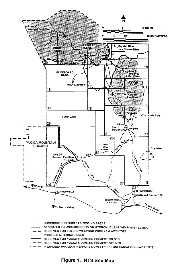
The original rectangular base of 6 by 10 miles (10 by 16 km) is now part of the so-called "Groom box", a rectangular area, measuring 23 by 25 miles (37 by 40 km), of restricted airspace. The area is connected to the internal Nevada Test Site (NTS) road network, with paved roads leading south to Mercury and west to Yucca Flat. Leading northeast from the lake, the wide and well-maintained Groom Lake Road runs through a pass in the Jumbled Hills. The road formerly led to mines in the Groom basin but has been improved since their closure. Its winding course runs past a security checkpoint, but the restricted area around the base extends farther east. After leaving the restricted area, Groom Lake Road descends eastward to the floor of the Tikaboo Valley, passing the dirt-road entrances to several small ranches, before converging with State Route 375, the "Extraterrestrial Highway", south of Rachel.[10]
Area 51 shares a border with the Yucca Flat region of the Nevada Test Site, the location of 739 of the 928 nuclear tests conducted by the United States Department of Energy at NTS.[11][12][13] The Yucca Mountain nuclear waste repository is southwest of Groom Lake.[14]
Groom Lake
Groom Lake is a salt flat[15] in Nevada used for runways of the Nellis Bombing Range Test Site airport (XTA/KXTA) on the north of the Area 51 USAF military installation. The lake at 4,409 ft (1,344 m) elevation is approximately 3+3⁄4 mi (6 km) from north to south and 3 mi (5 km) from east to west at its widest point.[16] Located within the namesake Groom Lake Valley portion of the Tonopah Basin, the lake is 25 mi (40 km) south of Rachel, Nevada.[17]
History
thumb|Nevada Test Range topographic chart centered on Groom Lake
The origin of the name "Area 51" is unclear. It is believed to be from an Atomic Energy Commission (AEC) numbering grid, although Area 51 is not part of this system; it is adjacent to Area 15. Another explanation is that 51 was used because it was unlikely that the AEC would use the number.[18] According to the Central Intelligence Agency (CIA), the correct names for the facility are Homey Airport (XTA/KXTA) and Groom Lake,[19][20] though the name "Area 51" was used in a CIA document from the Vietnam War.[21] The facility has also been referred to as "Dreamland" and "Paradise Ranch",[22] among other nicknames, with the former also being the approach control call sign for the surrounding area.[23][24] The USAF public relations has referred to the facility as "an operating location near Groom Dry Lake". The special use airspace around the field is referred to as Restricted Area 4808 North (R-4808N).[25]
Lead and silver were discovered in the southern part of the Groom Range in 1864,[26] and the English company Groome Lead Mines Limited financed the Conception Mines in the 1870s, giving the district its name (nearby mines included Maria, Willow, and White Lake).[27] J. B. Osborne and partners acquired the controlling interest in Groom in 1876, and Osborne's son acquired it in the 1890s.[27] Mining continued until 1918, then resumed after World War II until the early 1950s.[27]
The airfield on the Groom Lake site began service in 1942 as Indian Springs Air Force Auxiliary Field[28] and consisted of two unpaved 5,000-foot (1,524 m) runways.[29]
U-2 program

The Central Intelligence Agency (CIA) established the Groom Lake test facility in April 1955 for Project AQUATONE: the development of the Lockheed U-2 strategic reconnaissance aircraft. Project director Richard M. Bissell Jr. understood that the flight test and pilot training programs could not be conducted at Edwards Air Force Base or Lockheed's Palmdale facility, given the extreme secrecy surrounding the project. He conducted a search for a suitable testing site for the U-2 under the same extreme security as the rest of the project.[30]: 25 He notified Lockheed, who sent an inspection team out to Groom Lake. According to Lockheed's U-2 designer Kelly Johnson:[30] : 26
We flew over it and within thirty seconds, you knew that was the place [...] it was right by a dry lake. Man alive, we looked at that lake, and we all looked at each other. It was another Edwards, so we wheeled around, landed on that lake, taxied up to one end of it. It was a perfect natural landing field [...] as smooth as a billiard table without anything being done to it.
The lake bed made an ideal strip for testing aircraft, and the Emigrant Valley's mountain ranges and the NTS perimeter protected the site from visitors; it was about 100 mi (160 km) north of Las Vegas.[31] The CIA asked the AEC to acquire the land, designated "Area 51" on the map, and to add it to the Nevada Test Site.[9]: 56–57
Johnson named the area "Paradise Ranch" to encourage workers to move to "the new facility in the middle of nowhere", as the CIA later described it, and the name became shortened to "the Ranch".[9]: 57 On 4 May 1955, a survey team arrived at Groom Lake and laid out a 5,000-foot (1,500 m) north–south runway on the southwest corner of the lakebed and designated a site for a base support facility. The Ranch initially consisted of little more than a few shelters, workshops, and trailer homes in which to house its small team.[31] A little over three months later, the base consisted of a single paved runway, three hangars, a control tower, and rudimentary accommodations for test personnel. The base's few amenities included a movie theater and volleyball court. There was also a mess hall, several wells, and fuel storage tanks. CIA, Air Force, and Lockheed personnel began arriving by July 1955. The Ranch received its first U-2 delivery on 24 July 1955 from Burbank on a C-124 Globemaster II cargo plane, accompanied by Lockheed technicians on a Douglas DC-3.[31] Regular Military Air Transport Service flights were set up between Area 51 and Lockheed's offices in Burbank, California. To preserve secrecy, personnel flew to Nevada on Monday mornings and returned to California on Friday evenings.[9]: 72
OXCART program

Project OXCART was established in August 1959 for "antiradar studies, aerodynamic structural tests, and engineering designs" and all later work on the Lockheed A-12.[32] This included testing at Groom Lake, which had inadequate facilities consisting of buildings for only 150 people, a 5,000 ft (1,500 m) asphalt runway, and limited fuel, hangar, and shop space.[30]: 58 Groom Lake had received the name "Area 51"[30]: 59 [33] when A-12 test facility construction began in September 1960, including a new 8,500 ft (2,600 m) runway to replace the existing runway.[34]
Reynolds Electrical and Engineering Company (REECo) began construction of "Project 51" on 1 October 1960 with double-shift construction schedules. The contractor upgraded base facilities and built a new 10,000 ft (3,000 m) runway (14/32) diagonally across the southwest corner of the lakebed. They marked an Archimedean spiral on the dry lake approximately two miles across so that an A-12 pilot approaching the end of the overrun could abort instead of plunging into the sagebrush. Area 51 pilots called it "The Hook". For crosswind landings, they marked two unpaved airstrips (runways 9/27 and 03/21) on the dry lakebed.[35]
By August 1961, construction of the essential facilities was complete; three surplus Navy hangars were erected on the base's north side while hangar 7 was new construction. The original U-2 hangars were converted to maintenance and machine shops. Facilities in the main cantonment area included workshops and buildings for storage and administration, a commissary, a control tower, a fire station, and housing. The Navy also contributed more than 130 surplus Babbitt duplex housing units for long-term occupancy facilities. Older buildings were repaired, and additional facilities were constructed as necessary. A reservoir pond surrounded by trees served as a recreational area one mile north of the base. Other recreational facilities included a gymnasium, a movie theater, and a baseball diamond.[35] A permanent aircraft fuel tank farm was constructed by early 1962 for the special JP-7 fuel required by the A-12. Seven tanks were constructed, with a total capacity of 1,320,000 gallons.[30]: 58

Security was enhanced for the arrival of OXCART and the small mine was closed in the Groom basin. In January 1962, the Federal Aviation Administration (FAA) expanded the restricted airspace in the vicinity of Groom Lake, and the lakebed became the center of a 600-square mile addition to restricted area R-4808N.[35] The CIA facility received eight USAF F-101 Voodoos for training, two T-33 Shooting Star trainers for proficiency flying, a C-130 Hercules for cargo transport, a U-3A for administrative purposes, a helicopter for search and rescue, and a Cessna 180 for liaison use, and Lockheed provided an F-104 Starfighter for use as a chase plane.[35]
The first A-12 test aircraft was covertly trucked from Burbank on 26 February 1962 and arrived at Groom Lake on 28 February.[30]: 60 It made its first flight 26 April 1962 when the base had over 1,000 personnel.[30]: 60–62 The closed airspace above Groom Lake was within the Nellis Air Force Range airspace, and pilots saw the A-12 20 to 30 times.[30]: 63–64 Groom was also the site of the first Lockheed D-21 drone test flight on 22 December 1964.[30]: 123 By the end of 1963, nine A-12s were at Area 51, assigned to the CIA-operated "1129th Special Activities Squadron".[36]
D-21 Tagboard

Following the loss of Gary Powers' U-2 over the Soviet Union, there were several discussions about using the A-12 OXCART as an unpiloted drone aircraft. Although Kelly Johnson had come to support the idea of drone reconnaissance, he opposed the development of an A-12 drone, contending that the aircraft was too large and complex for such a conversion. However, the Air Force agreed to fund the study of a high-speed, high-altitude drone aircraft in October 1962. The Air Force interest seems to have moved the CIA to take action, the project designated "Q-12". By October 1963, the drone's design had been finalized. At the same time, the Q-12 underwent a name change. To separate it from the other A-12-based projects, it was renamed the "D-21". (The "12" was reversed to "21"). "Tagboard" was the project's code name.[30]: 121
The first D-21 was completed in the spring of 1964 by Lockheed. After four more months of checkouts and static tests, the aircraft was shipped to Groom Lake and reassembled. It was to be carried by a two-seat derivative of the A-12, designated the "M-21". When the D-21/M-21 reached the launch point, the first step would be to blow off the D-21's inlet and exhaust covers. With the D-21/M-21 at the correct speed and altitude, the LCO would start the ramjet and the other systems of the D-21. "With the D-21's systems activated and running, and the launch aircraft at the correct point, the M-21 would begin a slight pushover, the LCO would push a final button, and the D-21 would come off the pylon".[30]: 122
Difficulties were addressed throughout 1964 and 1965 at Groom Lake with various technical issues. Captive flights showed unforeseen aerodynamic difficulties. By late January 1966, more than a year after the first captive flight, everything seemed ready. The first D-21 launch was made on 5 March 1966 with a successful flight, with the D-21 flying 120 miles with limited fuel. A second D-21 flight was successful in April 1966 with the drone flying 1,200 miles, reaching Mach 3.3 and 90,000 feet. An accident on 30 July 1966 with a fully fueled D-21, on a planned checkout flight, suffered from an unstart of the drone after its separation, causing it to collide with the M-21 launch aircraft. The two crewmen ejected and landed in the ocean 150 miles offshore. One crew member was picked up by a helicopter, but the other, having survived the aircraft breakup and ejection, drowned when sea water entered his pressure suit. Kelly Johnson personally cancelled the entire program, having had serious doubts about its feasibility from the start. A number of D-21s had already been produced, and rather than scrapping the whole effort, Johnson again proposed to the Air Force that they be launched from a B-52H bomber.[30]: 125
By late summer of 1967, the modification work to both the D-21 (now designated D-21B) and the B-52Hs was complete. The test program could now resume. The test missions were flown out of Groom Lake, with the actual launches over the Pacific. The first D-21B to be flown was Article 501, the prototype. The first attempt was made on 28 September 1967 and ended in complete failure. As the B-52 was flying toward the launch point, the D-21B fell off the pylon. The B-52H gave a sharp lurch as the drone fell free. The booster fired and was "quite a sight from the ground". The failure was traced to a stripped nut on the forward right attachment point on the pylon. Several more tests were made, none of which met with success. However, the fact is that the resumptions of D-21 tests took place against a changing reconnaissance background. The A-12 had finally been allowed to deploy, and the SR-71 was soon to replace it. At the same time, new developments in reconnaissance satellite technology were nearing operation. Up to this point, the limited number of satellites available restricted coverage to the Soviet Union. A new generation of reconnaissance satellites could soon cover targets anywhere in the world. The satellites' resolution would be comparable to that of aircraft but without the slightest political risk. Time was running out for the Tagboard.[30]: 129
Several more test flights, including two over China, were made from Beale AFB, California, in 1969 and 1970, to varying degrees of success. On 15 July 1971, Kelly Johnson received a wire canceling the D-21B program. The remaining drones were transferred by a C-5A and placed in dead storage. The tooling used to build the D-21Bs was ordered destroyed. Like the A-12 Oxcart, the D-21B Tagboard drones remained a Black airplane, even in retirement. Their existence was not suspected until August 1976, when the first group was placed in storage at the Davis-Monthan AFB Military Storage and Disposition Center. A second group arrived in 1977. They were labeled "GTD-21Bs" (GT stood for ground training).[30]: 132
Davis-Monthan is an open base, with public tours of the storage area at the time, so the odd-looking drones were soon spotted and photos began appearing in magazines. Speculation about the D-21Bs circulated within aviation circles for years, and it was not until 1982 that details of the Tagboard program were released. However, it was not until 1993 that the B-52/D-21B program was made public. That same year, the surviving D-21Bs were released to museums.[30]: 132–133
Foreign technology evaluation
During the Cold War, one of the missions carried out by the United States was the test and evaluation of captured Soviet fighter aircraft. Beginning in the late 1960s, and for several decades, Area 51 played host to an assortment of Soviet-built aircraft.[citation needed]

Munir Redfa's defection with a Mikoyan-Gurevich MiG-21 from Iraq for Israel's Mossad in Operation Diamond led to the HAVE DOUGHNUT, HAVE DRILL and HAVE FERRY programs. The first MiGs flown in the United States were used to evaluate the aircraft in performance, technical, and operational capabilities, pitting the types against U.S. fighters.[37]
This was not a new mission, as testing of foreign technology by the USAF began during World War II. After the war, testing of acquired foreign technology was performed by the Air Technical Intelligence Center (ATIC, which became very influential during the Korean War), under the direct command of the Air Materiel Control Department. In 1961, ATIC became the Foreign Technology Division (FTD) and was reassigned to Air Force Systems Command. ATIC personnel were sent anywhere where foreign aircraft could be found. [citation needed]
The focus of Air Force Systems Command limited the use of the fighter as a tool with which to train the front line tactical fighter pilots.[37] Air Force Systems Command recruited its pilots from the Air Force Flight Test Center at Edwards Air Force Base, California, who were usually graduates from various test pilot schools. Tactical Air Command selected its pilots primarily from the ranks of the Weapons School graduates.[37]
In August 1966, Iraqi Air Force fighter pilot Captain Munir Redfa defected, flying his MiG-21 to Israel after being ordered to attack Iraqi Kurd villages with napalm. His aircraft was transferred to Groom Lake in late 1967 for study. Israel loaned the MiG-21 to the US Air Force from January 1968 to April 1968.[38] In 1968, the US Air Force and Navy jointly formed a project known as HAVE DOUGHNUT in which Air Force Systems Command, Tactical Air Command, and the U.S. Navy's Air Test and Evaluation Squadron Four (VX-4) flew this acquired Soviet-made aircraft in simulated air combat training.[37] As U.S. possession of the Soviet MiG-21 was, itself, secret, it was tested at Groom Lake. A joint Air Force-Navy team was assembled for a series of dogfight tests.[30]: 219

Comparisons between the F-4 and the MiG-21 indicated that, on the surface, they were evenly matched. The HAVE DOUGHNUT tests showed the skill of the man in the cockpit was what made the difference. When the Navy or Air Force pilots flew the MiG-21, the results were a draw; the F-4 would win some fights, the MiG-21 would win others. There were no clear advantages. The problem was not with the planes, but with the pilots flying them. The pilots would not fly either plane to its limits. One of the Navy pilots was Marland W. "Doc" Townsend, then commander of VF-121, the F-4 training squadron at NAS Miramar. He was an engineer and a Korean War veteran and had flown almost every Navy aircraft. When he flew against the MiG-21, he would outmaneuver it every time. The Air Force pilots would not go vertical in the MiG-21. The HAVE DOUGHNUT project officer was Tom Cassidy, a pilot with VX-4, the Navy's Air Development Squadron at Point Mugu. He had been watching as Townsend "waxed" the Air Force MiG-21 pilots. Cassidy climbed into the MiG-21 and went up against Townsend's F-4. This time the result was far different. Cassidy was willing to fight in the vertical, flying the plane to the point where it was buffeting, just above the stall. Cassidy was able to get on the F-4's tail. After the flight, they realized the MiG-21 turned better than the F-4 at lower speeds. The key was for the F-4 to keep its speed up. An F-4 had defeated the MiG-21; the weakness of the Soviet plane had been found. Further test flights confirmed what was learned. It was also clear that the MiG-21 was a formidable enemy. United States pilots would have to fly much better than they had been to beat it. This would require a special school to teach advanced air combat techniques.[30]: 220–221
On 12 August 1968, two Syrian air force lieutenants, Walid Adham and Radfan Rifai, took off in a pair of MiG-17Fs on a training mission. They lost their way and, believing they were over Lebanon, landed at the Betzet Landing Field in northern Israel. (One version has it that they were led astray by an Arabic-speaking Israeli).[30] Prior to the end of 1968 these MiG-17s were transferred from Israeli stocks and added to the Area 51 test fleet. The aircraft were given USAF designations and fake serial numbers so that they could be identified in DOD standard flight logs. As in the earlier program, a small group of Air Force and Navy pilots conducted mock dogfights with the MiG-17s. Selected instructors from the Navy's Top Gun school at NAS Miramar, California, were chosen to fly against the MiGs for familiarization purposes. Very soon, the MiG-17's shortcomings became clear. It had an extremely simple, even crude, control system that lacked the power-boosted controls of American aircraft. The F-4's twin engines were so powerful it could accelerate out of range of the MiG-17's guns in thirty seconds. It was important for the F-4 to keep its distance from the MiG-17. As long as the F-4 was one and a half miles from the MiG-17, it was outside the reach of the Soviet fighter's guns, but the MiG was within reach of the F-4's missiles.[30]: 222–225
The data from the HAVE DOUGHNUT and HAVE DRILL tests were provided to the newly formed Top Gun school at NAS Miramar. By 1970, the HAVE DRILL program was expanded; a few selected fleet F-4 crews were given the chance to fight the MiGs. The most important result of Project HAVE DRILL is that no Navy pilot who flew in the project defeated the MiG-17 Fresco in the first engagement. The HAVE DRILL dogfights were by invitation only. The other pilots based at Nellis Air Force Base were not to know about the U.S.-operated MiGs. To prevent any sightings, the airspace above the Groom Lake range was closed. On aeronautical maps, the exercise area was marked in red ink. The forbidden zone became known as "Red Square".[30]: 226
During the remainder of the Vietnam War, the Navy kill ratio climbed to 8.33 to 1. In contrast, the Air Force rate improved only slightly to 2.83 to 1. The reason for this difference was Top Gun. The Navy had revitalized its air combat training, while the Air Force had stayed stagnant. Most of the Navy MiG kills were by Top Gun graduates.[30]: 231
In May 1973, Project HAVE IDEA was formed, which took over from the older HAVE DOUGHNUT, HAVE FERRY and HAVE DRILL projects, and the project was transferred to the Tonopah Test Range Airport. At Tonopah, testing of foreign technology aircraft continued and expanded throughout the 1970s and 1980s.[37]
Area 51 also hosted another foreign materiel evaluation program called HAVE GLIB. This involved testing Soviet tracking and missile control radar systems. A complex of actual and replica Soviet-type threat systems began to grow around "Slater Lake", a mile northwest of the main base, along with an acquired Soviet "Barlock" search radar placed at Tonopah Air Force Station. They were arranged to simulate a Soviet-style air defense complex.[37]
The Air Force began funding improvements to Area 51 in 1977 under project SCORE EVENT. In 1979, the CIA transferred jurisdiction of the Area 51 site to the Air Force Flight Test Center at Edwards AFB, California. Sam Mitchell, the last CIA commander of Area 51, relinquished command to USAF Lt. Col. Larry D. McClain.[37]
In 2017, a USAF aircraft crashed at the site, killing the pilot, Lt. Colonel Eric "Doc" Schultz. The USAF refused to release further information regarding the crash. In 2022, unconfirmed reports emerged that the crash involved an SU-27 that was part of the classified Foreign Materials Exploitation program. The reports claimed that the aircraft suffered a technical issue that resulted in both crew members ejecting from the aircraft, resulting in the death of Schultz.[39]
Have Blue/F-117 program
The Lockheed Have Blue prototype stealth fighter (a smaller proof-of-concept model of the F-117 Nighthawk) first flew at Groom in December 1977.[40]

In 1978, the Air Force awarded a full-scale development contract for the F-117 to Lockheed Corporation's Advanced Development Projects. On 17 January 1981 the Lockheed test team at Area 51 accepted delivery of the first full-scale development (FSD) prototype 79–780, designated YF-117A. At 6:05 am on 18 June 1981 Lockheed Skunk Works test pilot Hal Farley lifted the nose of YF-117A 79–780 off the runway of Area 51.[41]
Meanwhile, Tactical Air Command (TAC) decided to set up a group-level organization to guide the F-117A to an initial operating capability. That organization became the 4450th Tactical Group (Initially designated "A Unit"), which officially activated on 15 October 1979 at Nellis AFB, Nevada, although the group was physically located at Area 51. The 4450th TG also operated the A-7D Corsair II as a surrogate trainer for the F-117A, and these operations continued until 15 October 1982 under the guise of an avionics test mission.[41]
Flying squadrons of the 4450th TG were the 4450th Tactical Squadron (Initially designated "I Unit") activated on 11 June 1981, and 4451st Tactical Squadron (Initially designated "P Unit") on 15 January 1983. The 4450th TS, stationed at Area 51, was the first F-117A squadron, while the 4451st TS was stationed at Nellis AFB and was equipped with A-7D Corsair IIs painted in a dark motif, tail coded "LV". Lockheed test pilots put the YF-117 through its early paces. A-7Ds were used for pilot training before any F-117As had been delivered by Lockheed to Area 51, later the A-7D's were used for F-117A chase testing and other weapon tests at the Nellis Range. On 15 October 1982, Major Alton C. Whitley Jr. became the first USAF 4450th TG pilot to fly the F-117A.[41]
Although ideal for testing, Area 51 was not a suitable location for an operational group, so a new covert base had to be established for F-117 operations.[42] Tonopah Test Range Airport was selected for operations of the first USAF F-117 unit, the 4450th Tactical Group (TG).[43] From October 1979, the Tonopah Airport base was reconstructed and expanded. The 6,000-foot runway was lengthened to 10,000 feet. Taxiways, a concrete apron, a large maintenance hangar, and a propane storage tank were added.[44]
By early 1982, four more YF-117As were operating at the base.[30]: 162 After finding a large scorpion in their offices, the testing team (Designated "R Unit") adopted it as their mascot and dubbed themselves the "Baja Scorpions".[45] Testing of a series of ultra-secret prototypes continued at Area 51 until mid-1981 when testing transitioned to the initial production of F-117 stealth fighters. The F-117s were moved to and from Area 51 by C-5 during darkness to maintain security. The aircraft were defueled, disassembled, cradled, and then loaded aboard the C-5 at night, flown to Lockheed, and unloaded at night before reassembly and flight testing. Groom performed radar profiling, F-117 weapons testing, and training of the first group of frontline USAF F-117 pilots.[30]: 161
While the "Baja Scorpions" were working on the F-117, there was also another group at work in secrecy, known as "the Whalers" working on Tacit Blue. A fly-by-wire technology demonstration aircraft with curved surfaces and composite material, to evade radar, was a prototype, and never went into production. Nevertheless, this strange-looking aircraft was responsible for many of the stealth technology advances that were used on several other aircraft designs, and had a direct influence on the B-2; with the first flight of Tacit Blue being performed on 5 February 1982, by Northrop Grumman test pilot, Richard G. Thomas.[30]: 249–250
Production FSD airframes from Lockheed were shipped to Area 51 for acceptance testing. As the Baja Scorpions tested the aircraft with functional check flights and L.O. verification, the operational airplanes were then transferred to the 4450th TG.[45]

On 17 May 1982, the move of the 4450th TG from Groom Lake to Tonopah was initiated, with the final components of the move completed in early 1983. Production FSD airframes from Lockheed were shipped to Area 51 for acceptance testing. As the Baja Scorpions tested the aircraft with functional check flights and L.O. verification, the operational airplanes were then transferred to the 4450th TG at Tonopah.[45]
The R-Unit was inactivated on 30 May 1989. Upon inactivation, the unit was reformed as Detachment 1, 57th Fighter Weapons Wing (FWW). In 1990, the last F-117A (843) was delivered from Lockheed. After completion of acceptance flights at Area 51 of this last new F-117A aircraft, the flight test squadron continued flight test duties of refurbished aircraft after modifications by Lockheed. In February/March 1992 the test unit moved from Area 51 to the USAF Palmdale Plant 42 and was integrated with the Air Force Systems Command 6510th Test Squadron. Some testing, especially RCS verification and other classified activity was still conducted at Area 51 throughout the operational lifetime of the F-117. The recently inactivated (2008) 410th Flight Test Squadron traces its roots, if not its formal lineage to the 4450th TG R-unit.[45]
Later operations

Since the F-117 became operational in 1983, operations at Groom Lake have continued. The base and its associated runway system were expanded, including the expansion of housing and support facilities.[20][46] In 1995, the federal government expanded the exclusionary area around the base to include nearby mountains that had hitherto afforded the only decent overlook of the base, prohibiting access to 3,972 acres (16.07 km2) of land formerly administered by the Bureau of Land Management.[20]
Legal status
U.S. government's positions on Area 51


The United States government has provided minimal information regarding Area 51. The area surrounding the lake is permanently off-limits to both civilian and normal military air traffic. Security clearances are checked regularly; cameras and weaponry are not allowed.[7] Even military pilots training in the NAFR risk disciplinary action if they stray into the exclusionary "box" surrounding Groom's airspace.[7] Surveillance is supplemented using buried motion sensors.[47] Area 51 is a common destination for Janet, a small fleet of passenger aircraft operated on behalf of the Air Force to transport military personnel, primarily from Harry Reid International Airport.[48]
The United States Geological Survey (USGS) topographic map for the area only shows the long-disused Groom Mine,[49] but USGS aerial photographs of the site in 1959 and 1968 were publicly available.[50] A civil aviation chart published by the Nevada Department of Transportation shows a large restricted area, defined as part of the Nellis restricted airspace.[51] The National Atlas shows the area as lying within the Nellis Air Force Base.[52] There are higher resolution and newer images available from other satellite imagery providers, including Russian providers and the IKONOS.[20] These show the runway markings, base facilities, aircraft, and vehicles.[20]
In 1998 USAF officially acknowledged the site's existence.[50] On 25 June 2013, the CIA released an official history of the U-2 and OXCART projects which acknowledged that the U-2 was tested at Area 51, in response to a Freedom of Information Act request submitted in 2005 by Jeffrey T. Richelson of George Washington University's National Security Archive. It contains numerous references to Area 51 and Groom Lake, along with a map of the area.[9] Media reports stated that releasing the CIA history was the first governmental acknowledgement of Area 51's existence;[53][54][15] rather, it was the first official acknowledgement of specific activity at the site.[50]
Environmental lawsuit
In 1994, five unnamed civilian contractors and the widows of contractors Walter Kasza and Robert Frost sued the Air Force and the United States Environmental Protection Agency. They alleged that they had been present when large quantities of unknown chemicals had been burned in open pits and trenches at Groom. Rutgers University biochemists analyzed biopsies from the complainants and found high levels of dioxin, dibenzofuran, and trichloroethylene in their body fat. The complainants alleged that they had sustained skin, liver, and respiratory injuries due to their work at Groom and that this had contributed to the deaths of Frost and Kasza. The suit sought compensation for the injuries, claiming that the Air Force had illegally handled toxic materials and that the EPA had failed in its duty to enforce the Resource Conservation and Recovery Act which governs the handling of dangerous materials. They also sought detailed information about the chemicals, hoping that this would facilitate the medical treatment of survivors.[55] Congressman Lee H. Hamilton, former chairman of the House Intelligence Committee, told 60 Minutes reporter Lesley Stahl, "The Air Force is classifying all information about Area 51 in order to protect themselves from a lawsuit."[56]
The government invoked the State Secrets Privilege and petitioned U.S. District Judge Philip Pro to disallow disclosure of classified documents or examination of secret witnesses, claiming that this would expose classified information and threaten national security.[57] Judge Pro rejected the government's argument, so President Bill Clinton issued a Presidential Determination exempting what it called "the Air Force's Operating Location Near Groom Lake, Nevada" from environmental disclosure laws. Consequently, Pro dismissed the suit due to lack of evidence. Jonathan Turley, the attorney who was handling the lawsuit, appealed to the U.S. Court of Appeals for the Ninth Circuit on the grounds that the government was abusing its power to classify material. Secretary of the Air Force Sheila E. Widnall filed a brief which stated that disclosures of the materials present in the air and water near Groom "can reveal military operational capabilities or the nature and scope of classified operations." The Ninth Circuit rejected Turley's appeal[58] and the U.S. Supreme Court refused to hear it, putting an end to the complainants' case.[55]
The President annually issues a determination continuing the Groom exception[59][60][61] which is the only formal recognition that the government has ever given that Groom Lake is more than simply another part of the Nellis complex. An unclassified memo on the safe handling of F-117 Nighthawk material was posted on an Air Force web site in 2005. This discussed the same materials for which the complainants had requested information, which the government had claimed was classified. The memo was removed shortly after journalists became aware of it.[62]
Civil aviation identification
In December 2007, airline pilots noticed that the base had appeared in their aircraft navigation systems' latest Jeppesen database revision with the ICAO airport identifier code of KXTA and listed as "Homey Airport".[63] The probably inadvertent release of the airport data led to advice by the Aircraft Owners and Pilots Association (AOPA) that student pilots should be explicitly warned about KXTA, not to consider it as a waypoint or destination for any flight even though it now appears in public navigation databases.[63]
Security

The perimeter of the base is marked out by orange posts and patrolled by guards in white pickup trucks and camouflage fatigues. The guards are popularly referred to as "camo dudes" by enthusiasts.[64][65] The guards will not answer questions about their employers; however, according to the New York Daily News, there are indications they are employed through a contractor such as AECOM.[65][66] Signage around the base perimeter advises that deadly force is authorized against trespassers.[67]
Technology is also heavily used to maintain the border of the base; this includes surveillance cameras and motion detectors. Some of these motion detectors are placed some distance away from the base on public land to notify guards of people approaching.[68]

1974 Skylab photography
Dwayne A. Day published "Astronauts and Area 51: the Skylab Incident" in The Space Review in January 2006. It was based on a memo written in 1974 to CIA director William Colby by an unknown CIA official. The memo reported that astronauts on board Skylab had inadvertently photographed a certain location:[69]
There were specific instructions not to do this. [redacted] was the only location which had such an instruction.
The name of the location was obscured,[lower-alpha 2] but the context led Day to believe that the subject was Groom Lake. Day wrote that "the CIA considered no other spot on Earth to be as sensitive as Groom Lake". Even within the agency's National Photographic Interpretation Center that handled classified reconnaissance satellite photographs, images of the site were removed from film rolls and stored separately as not all photo interpreters had security clearance for the information.[69][71] The memo details debate between federal agencies regarding whether the images should be classified, with Department of Defense agencies arguing that it should and NASA and the State Department arguing that it should not be classified. The memo itself questions the legality of retroactively classifying unclassified images.[69]
The memo includes handwritten remarks,[72] apparently by Director of Central Intelligence Colby:
[Secretary of State Rusk] did raise it—said State Dept. people felt strongly. But he inclined leave decision to me (DCI)—I confessed some question over need to protect since:
- USSR has it from own sats
- What really does it reveal?
- If exposed, don't we just say classified USAF work is done there?
The declassified documents do not disclose the outcome of discussions regarding the Skylab imagery. The debate proved moot, as the photograph appeared in the Federal Government's Archive of Satellite Imagery along with the remaining Skylab photographs.[73]
2019 shooting incident
On 28 January 2019, an unidentified man drove through a security checkpoint near Mercury, Nevada, in an apparent attempt to enter the base. After an 8-mile (13-kilometer) vehicle pursuit by base security, the man exited his vehicle carrying a "cylindrical object" and was shot dead by NNSS security officers and sheriff's deputies after refusing to obey requests to halt. There were no other injuries reported.[74][75]
UFO and other conspiracy theories

Area 51 has become a focus of modern conspiracy theories due to its secretive nature and connection to classified aircraft research.[8] Theories include:
- The storage, examination, and reverse engineering of crashed alien spacecraft, including material supposedly recovered at Roswell, the study of their occupants, and the manufacture of aircraft based on alien technology
- Meetings or joint undertakings with extraterrestrials
- The development of exotic energy weapons for the Strategic Defense Initiative (SDI) or other weapons programs
- The development of weather control
- The development of time travel and teleportation technology
- The development of exotic propulsion systems related to the Aurora Program
- Activities related to the conspiracy theory of a one-world government

Many of the hypotheses concern underground facilities at Groom or at Papoose Lake (also known as "S-4 location"), 8.5 miles (13.7 km) south, and include claims of a transcontinental underground railroad system, a disappearing airstrip nicknamed the "Cheshire Airstrip", after Lewis Carroll's Cheshire cat, which briefly appears when water is sprayed onto its camouflaged asphalt, and engineering based on alien technology.[76]
In the mid-1950s, civilian aircraft flew under 20,000 feet while military aircraft flew up to 40,000 feet. The U-2 began flying above 60,000 feet and there was an increasing number of UFO sighting reports. Sightings occurred most often during early evening hours, when airline pilots flying west saw the U-2's silver wings reflect the setting sun, giving the aircraft a "fiery" appearance. Many sighting reports came to the Air Force's Project Blue Book, which investigated UFO sightings, through air-traffic controllers and letters to the government. The project checked U-2 and later OXCART flight records to eliminate the majority of UFO reports that it received during the late 1950s and 1960s, although it could not reveal to the letter writers the truth behind what they saw.[9]: 72–73 Similarly, veterans of experimental projects such as OXCART at Area 51 agree that their work inadvertently prompted many of the UFO sightings and other rumors:[77]
The shape of OXCART was unprecedented, with its wide, disk-like fuselage designed to carry vast quantities of fuel. Commercial pilots cruising over Nevada at dusk would look up and see the bottom of OXCART whiz by at 2,000-plus mph. The aircraft's titanium body, moving as fast as a bullet, would reflect the sun's rays in a way that could make anyone think, UFO.[78]
They believe that the rumors helped maintain secrecy over Area 51's actual operations.[7] The veterans deny the existence of a vast underground railroad system,[78] although many of Area 51's operations did occur underground.[79]

Bob Lazar claimed in 1989 that he had worked at Area 51's "Sector Four (S-4)", said to be located underground inside the Papoose Range near Papoose Lake. He claimed that he was contracted to work with alien spacecraft that the government had in its possession.[80] Similarly, the 1996 documentary Dreamland directed by Bruce Burgess included an interview with a 71-year-old mechanical engineer who claimed to be a former employee at Area 51 during the 1950s. His claims included that he had worked on a "flying disc simulator" which had been based on a disc originating from a crashed extraterrestrial craft and was used to train pilots. He also claimed to have worked with an extraterrestrial being named "J-Rod" and described as a "telepathic translator".[81] In 2004, Dan Burisch (pseudonym of Dan Crain) claimed to have worked on cloning alien viruses at Area 51, also alongside the alien named "J-Rod". Burisch's scholarly credentials are the subject of much debate, as he was apparently working as a Las Vegas parole officer in 1989 while also earning a PhD at State University of New York (SUNY).[82]
In July 2019, more than 2,000,000 people responded to a joke proposal to storm Area 51 which appeared in an anonymous Facebook post.[83][84][85] The event, scheduled for 20 September 2019, was billed as "Storm Area 51, They Can't Stop All of Us", an attempt to "see them aliens".[86][87] Air Force spokeswoman Laura McAndrews said the government "would discourage anyone from trying to come into the area where we train American armed forces".[3] Two music festivals in rural Nevada, AlienStock and Storm Area 51 Basecamp, were subsequently organized to capitalize on the popularity of the original Facebook event. Between 1,500 and 3,000 people showed up at the festivals, while over 150 people made the journey over several miles of rough roads to get near the gates to Area 51.[88][89] Seven people were reportedly arrested at the event.[88]
In popular culture
Because of Area 51's prominence in relation to aliens and conspiracy theories, it has often been used as a setting and theme in popular culture, especially in science fiction works involving aliens.[90]
See also
- Area 52
- Black operation
- Black project
- Black site
- List of United States Air Force installations
- Special access program
Footnotes
Citations
- ↑ Cherif, Mohamed (30 May 2015). UFOs: Aliens or Extraterrestrials. TheBookEdition. p. 345. ISBN 9789938052633.
- ↑ 2.0 2.1 2.2 "KXTA" (PDF). Jeppesen. 8 January 2021. Archived from the original (PDF) on 31 July 2021. Retrieved 31 August 2021.
- ↑ 3.0 3.1 3.2 Brice-Saddler, Michael (12 July 2019). "Half a million people signed up to storm Area 51. What happens if they actually show?". The Washington Post. Retrieved 13 July 2019.
- ↑ Rich & Janos 1994, p. 57.
- ↑ "Area 51 'declassified' in U-2 spy plane history". BBC News. 16 August 2013. Archived from the original on 15 October 2014. Retrieved 25 September 2014.
- ↑ Jacobsen 2012, pp. 11–15, 320–321.
- ↑ 7.0 7.1 7.2 7.3 Lacitis, Erik (27 March 2010). "Area 51 vets break silence: Sorry, but no space aliens or UFOs". Seattle Times Newspaper. Archived from the original on 20 June 2012. Retrieved 10 June 2013.
- ↑ 8.0 8.1 Jacobsen 2012, pp. 65–66, 77–80.
- ↑ 9.0 9.1 9.2 9.3 9.4 9.5 Pedlow, Gregory W.; Welzenbach, Donald E. (1992). The Central Intelligence Agency and Overhead Reconnaissance: The U-2 and OXCART Programs, 1954–1974. Washington DC: History Staff, Central Intelligence Agency. Archived from the original on 18 August 2013. Retrieved 17 August 2013.
- ↑ Regenold, Stephen (13 April 2007). "Lonesome Highway to Another World?". The New York Times. Archived from the original on 17 June 2007. Retrieved 8 July 2007.
- ↑ "US Department of Energy. Nevada Operations Office. United States Nuclear Tests: July 1945 through September 1992 (December 2000)" (PDF). Archived from the original (PDF) on 15 June 2010. Retrieved 10 June 2010.
- ↑ "Navigation map". ndep.nv.gov. Archived from the original on 16 February 2008. Retrieved 4 October 2008.
- ↑ "Guide" (GIF). fas.org. Archived from the original on 6 November 2015. Retrieved 4 April 2015.
- ↑ Farnham, Alan (15 August 2013). "Area 51, 25 Among Yucca Mountain's Nuclear Neighbors". abc News. Retrieved 20 December 2020.
- ↑ 15.0 15.1 Leiby, Richard (24 August 2017). "Government officially acknowledges existence of Area 51, but not the UFOs". The Washington Post. Archived from the original on 7 August 2017. Retrieved 16 July 2019.
- ↑ "Groom Lake". Geographic Names Information System. United States Geological Survey, United States Department of the Interior. Retrieved 9 November 2010.
- ↑ Merlin, Peter (16 October 2010). "DREAMLAND: Fifty Years of Secret Flight Testing in NevadaBy Peter W. Merlin". dreamlandresort.com. Retrieved 7 January 2021.
- ↑ Strickland, Jonathan. "How Area 51 Works". How Stuff Work. Archived from the original on 21 August 2013. Retrieved 16 August 2013.
- ↑ "Intelligence Officer's Bookshelf". CIA.gov. 11 June 2013. Archived from the original on 3 December 2013. Retrieved 15 July 2019.
- ↑ 20.0 20.1 20.2 20.3 20.4 "Overhead: Groom Lake – Area 51". Federation of American Scientists. Archived from the original on 5 June 2013. Retrieved 11 June 2013.
- ↑ Helms, Richard (15 May 1967). ""OXCART reconnaissance of North Vietnam", Memo to the Deputy Secretary of Defense from the office of CIA Director Richard Helms, 15 May 1967". FOIA.CIA.gov. Archived from the original on 15 October 2012. Retrieved 15 July 2019. (the full declassified document is mirrored at Wikimedia Commons)
- ↑ Rich, Ben R; Janos, Leo (1994). Skunk Works: A personal memoir of my years at Lockheed. Boston: Little, Brown. p. 56. ISBN 978-0-316-74300-6.
- ↑ 99th Air Base Wing (17 June 2022). Nellis Air Force Base Instruction 11-250 (PDF). Las Vegas: United States Air Force. p. 105. Archived (PDF) from the original on 16 July 2022.
{{cite book}}: CS1 maint: numeric names: authors list (link) - ↑ Nevada Test and Training Range (24 July 2020). Air Force Manual 13-212 Volume 1 ACC Supplement NTTR Addendum A (PDF). Las Vegas: United States Air Force. p. 16. Archived (PDF) from the original on 31 July 2022. Retrieved 31 July 2022.
- ↑ "Flight Planning / Aeronautical Charts". SkyVector. Archived from the original on 3 December 2013. Retrieved 11 June 2013.
- ↑ Tingley, Joseph. "Mineral resources of the pahranagat range 30' by 60' quadrangle" (PDF). University of Nevada-Reno. Archived from the original (PDF) on 15 April 2012. Retrieved 15 January 2021.
- ↑ 27.0 27.1 27.2 "Groom Mining District Collection 99-19". Knowledgecenter.unr.edu. Archived from the original on 12 March 2013. Retrieved 10 June 2013.
- ↑ Mueller, Robert (1989). Active Air Force Bases Within the United States of America on 17 September 1982 (PDF). Maxwell AFB, Alabama: Center for Air Force History, USAF. ISBN 0-912799-53-6. Archived (PDF) from the original on 20 December 2016. Retrieved 23 December 2016.
- ↑ "WW2 Military Airfields including Auxiliaries and Support fields". Airfieldsdatabase.com. Archived from the original on 8 June 2012. Retrieved 10 June 2012.
- ↑ 30.00 30.01 30.02 30.03 30.04 30.05 30.06 30.07 30.08 30.09 30.10 30.11 30.12 30.13 30.14 30.15 30.16 30.17 30.18 30.19 30.20 30.21 30.22 30.23 Peebles, Curtis (1999). Dark Eagles, Revised Edition. Novato, CA: Presidio Press. ISBN 0-89141-696-X.
- ↑ 31.0 31.1 31.2 Peebles, Curtis (2000). Shadow Flights: America's Secret Air War Against the Soviet Union. Novato, CA: Presidio Press. pp. 141–144. ISBN 978-0-89141-700-2.
- ↑ The U-2's Intended Successor: Project Oxcart, 1956–1968 (Report). October 1994.
- ↑ "Area 51's existence acknowledged by CIA in declassified documents". CBS News. 16 August 2013. Retrieved 27 November 2020.
- ↑ "OSA History, chap. 20, pp. 39–40, 43, 51 ... "OXCART Story" pp. 7–9 (S) (cited by "The U-2's Intended Successor")
- ↑ 35.0 35.1 35.2 35.3 McIninch, Thomas P. (2 July 1996). "The Oxcart Story". CIA.gov. Archived from the original on 4 October 2013. Retrieved 15 July 2019.
- ↑ "U-2 and SR-71 Units, Bases and Detachments". Ais.org. 1995. Archived from the original on 7 May 2013. Retrieved 10 June 2013.
- ↑ 37.0 37.1 37.2 37.3 37.4 37.5 37.6 Steve Davies: "Red Eagles. America's Secret MiGs", Osprey Publishing, 2008
- ↑ Rosen, Benji (1 November 2013). "Israel loaned Soviet jets to US for testing in 1968". The Jerusalem Post. Retrieved 22 December 2022.
- ↑ "Area 51 Test Pilot Died During Heroic Su-27 Flight: Report". The Drive. 7 May 2022.
- ↑ Rich & Janos 1994, pp. 56–60.
- ↑ 41.0 41.1 41.2 "Info" (PDF). www.usafpatches.com. Archived (PDF) from the original on 6 November 2015. Retrieved 6 September 2011.
- ↑ "Area 51 Test Site". F-117A. 14 July 2003. Archived from the original on 22 October 2013. Retrieved 10 June 2013.
- ↑ "4450th TG". F-117A. 1 April 2002. Archived from the original on 22 October 2013. Retrieved 10 June 2013.
- ↑ "Tonopah Test Range (TTR)". F-117A. 14 July 2003. Archived from the original on 22 October 2013. Retrieved 10 June 2013.
- ↑ 45.0 45.1 45.2 45.3 "JTF "Baja Scorpions" of Groom Lake". F-117A. 14 July 2003. Archived from the original on 4 June 2012. Retrieved 10 June 2013.
- ↑ Mary Motta (22 April 2000). "Images of Top-Secret U.S. Air Base Show Growth". space.com. Archived from the original on 26 September 2001.
- ↑ Kevin Poulsen (25 May 2004). "Area 51 hackers dig up trouble". Securityfocus.com. Archived from the original on 30 November 2012. Retrieved 10 June 2013.
- ↑ "Janet Airline / EG&G / JT3". dreamlandresort.com. 5 November 2020. Retrieved 8 January 2021.
- ↑ "Groom Mine, NV – N37.34583° W115.76583°". Topoquest.com. Retrieved 10 June 2013.
- ↑ 50.0 50.1 50.2 Day, Dwayne Allen (23 January 2023). "Not-so ancient astronauts and Area 51: the Skylab Incident". The Space Review. Retrieved 24 January 2023.
- ↑ "State of Nevada Aeronautical Chart 2013-2014" (PDF). Archived from the original (PDF) on 25 April 2013. Retrieved 11 June 2013.
- ↑ nationalatlas.gov. "Map of Federal lands in Nevada" (PDF). US Department of the Interior. Archived from the original (PDF) on 10 September 2013. Retrieved 10 June 2013.
- ↑ "CIA acknowledges its mysterious Area 51 test site for first time". Reuters Archive. 17 August 2013. Archived from the original on 17 August 2013. Retrieved 17 August 2013.
- ↑ "Area 51 officially acknowledged, mapped in newly released documents". CNN. Archived from the original on 17 August 2013. Retrieved 17 August 2013.
- ↑ 55.0 55.1 "High court won't review "state secrets" privilege in 'Area 51' case". RCFP.org. 16 November 1998. Retrieved 31 December 2020.
- ↑ "60 Minutes Transcript an Area 51". ufomind.com. 17 March 1996. Retrieved 31 December 2020.
- ↑ Rogers, Keith (4 June 2002). "Federal judges to hear case involving Area 51". Las Vegas Review-Journal. Archived from the original on 14 February 2010. Retrieved 10 June 2013.
- ↑ "Appeal from the United States District Court for the District of Nevada, Philip M. Pro, District Judge, Presiding. Argued and Submitted June 14, 2002" (PDF). 14 March 2012. Archived from the original (PDF) on 14 March 2012.
- ↑ "2000 Presidential Determination". Archived from the original on 4 June 2012. Retrieved 10 June 2010.
- ↑ "2002 Presidential Determination". Georgewbush-whitehouse.archives.gov. 18 September 2002. Archived from the original on 15 June 2011. Retrieved 10 June 2010.
- ↑ "2003 Presidential Determination". Georgewbush-whitehouse.archives.gov. 16 September 2003. Archived from the original on 10 May 2010. Retrieved 10 June 2010.
- ↑ "Warnings for emergency responders kept from Area 51 workers". Las Vegas Review-Journal. 21 May 2006. Archived from the original on 14 February 2010. Retrieved 10 June 2013.
- ↑ 63.0 63.1 Marsh, Alton K. (10 January 2008). "Don't ask, don't tell: Area 51 gets airport identifier – Aircraft Owners and Pilots Association". Aopa.org. Archived from the original on 12 May 2013. Retrieved 10 June 2013.
- ↑ Webster, Donovan (26 June 1994). "Area 51". The New York Times.
- ↑ 65.0 65.1 "Here's what we know about the 'Cammo Dudes' who patrol Area 51". nydailynews.com. Archived from the original on 6 August 2018. Retrieved 6 August 2018.
- ↑ "Area 51 Camo Dudes: Lethal Force Authorized – Area 51". area51.org. 9 January 2017. Archived from the original on 6 August 2018. Retrieved 6 August 2018.
- ↑ Hearst Magazines (April 2000). Popular Mechanics. Hearst Magazines. pp. 142–.
- ↑ "Area 51 'hacker' charges dropped". theregister.co.uk. Archived from the original on 6 August 2018. Retrieved 6 August 2018.
- ↑ 69.0 69.1 69.2 Day, Dwayne A. (9 January 2006). "Astronauts and Area 51: the Skylab Incident". The Space Review (online). Archived from the original on 16 March 2006. Retrieved 2 April 2006.
- ↑ Jacobsen 2012, p. xvi.
- ↑ "Presidential Determination No. 2003–39". Georgewbush-whitehouse.archives.gov. 16 September 2003. Archived from the original on 10 May 2010. Retrieved 10 June 2010.
- ↑ "CIA memo to DCI Colby" (PDF). Hosted by The Space Review. Archived (PDF) from the original on 26 March 2006. Retrieved 2 April 2006.
- ↑ Day, Dwayne A. (26 November 2007). "Secret Apollo". The Space Review (online). Archived from the original on 12 July 2009. Retrieved 16 February 2009.
- ↑ Martin, Sean (16 July 2019). "Area 51 warning: Man shot dead for trying to enter military base". Express. Archived from the original on 17 July 2019. Retrieved 11 August 2021.
- ↑ Shoro, Mike (28 January 2019). "Chase at Nevada National Security Site ends with man shot dead". Las Vegas Review-Journal. Archived from the original on 29 January 2019. Retrieved 11 August 2021.
- ↑ Mahood, Tom (October 1996). "The Cheshire Airstrip". Archived from the original on 16 March 2006. Retrieved 2 April 2006.
- ↑ Jacobsen 2012, pp. 204–208.
- ↑ 78.0 78.1 Jacobsen, Annie (5 April 2009). "The Road to Area 51". Los Angeles Times. Archived from the original on 21 January 2012. Retrieved 10 June 2013.
- ↑ Jacobsen 2012, pp. 364–366.
- ↑ Knapp, George (10 November 1989). "Bob Lazar describes alien technology housed at secret S-4 base in Nevada" (video). youtube.com. KLAS-TV.
- ↑ Dreamland, Transmedia and Dandelion Production for Sky Television (1996).
- ↑ Sheaffer, Robert (November–December 2004). "Tunguska 1, Roswell 0". Skeptical Inquirer. 28 (6). Committee for Skeptical Inquiry. Archived from the original on 13 March 2009.
- ↑ van Boom, Daniel (18 July 2019). "1.7 million want to raid Area 51 to 'see them aliens'". CNET News. Retrieved 23 July 2019.
- ↑ Matei, Adrienne (17 July 2019). "1.5 million people have signed up to storm Area 51. What could go wrong?". The Guardian.
- ↑ Griffin, Andrew (17 July 2019). "Storm Area 51: Are Alien-hunters Really Planning to 'Raid' the Secret U.S. Military Base?". The Independent.
- ↑ Matei, Adrienne (16 July 2019). "1.3 million people have signed up to storm Area 51. What could go wrong?". The Guardian. ISSN 0261-3077. Retrieved 16 July 2019.
- ↑ "Storm Area 51, They Can't Stop All of Us". m.facebook.com. Retrieved 25 July 2019.
- ↑ 88.0 88.1 Richwine, Lisa (20 September 2019). "Area 51 raid lures festive UFO hunters to Nevada desert; five arrested". Reuters. Retrieved 22 September 2019.
- ↑ Zialcita, Paolo (20 September 2019). "'Storm Area 51' Fails To Materialize". NPR. Retrieved 21 September 2019.
- ↑ Ward, Alex (19 September 2019). "Area 51 and aliens: the myth, the meme, and the strange reality, explained". Vox. Retrieved 20 February 2024.
Sources
- Darlington, David (1998). Area 51: The Dreamland Chronicles. New York: Henry Holt. ISBN 978-0-8050-6040-9
- Jacobsen, Annie (2012) [2011]. Area 51: An Uncensored History of America's Top Secret Military Base. New York: Back Bay Books. ISBN 978-0-316-13294-7.
- Patton, Phil (1998). Dreamland: Travels Inside the Secret World of Roswell and Area 51. New York: Villard/Random House ISBN 978-0-375-75385-5
- Rich, Ben R.; Janos, Leo (1994). Skunk Works: A personal memoir of my years at Lockheed. Boston: Little, Brown. ISBN 978-0-316-74300-6.
- Stahl, Lesley "Area 51 / Catch 22" 60 Minutes CBS Television 17 March 1996, a US TV news magazine's segment about the environmental lawsuit.
External links
 Media related to Category:Area 51 at Wikimedia Commons
- Las Vegas sectional aeronautical chart, centered on Groom Lake (Federal Aviation Administration – SkyVector.com)
| Claimed sightings | |
|---|---|
| General | |
| Pre-20th century | |
| 20th century | |
| |
| Confirmed hoaxes | |
| Sightings by country | |
| Types of UFOs | |
| Types of alleged extraterrestrial beings | |
| Studies and timeline | |
| |
| Hypotheses | |
| Conspiracy theories | |
| Involvement | |
| Abduction claims | |
| Other | |
| Culture | |
| Skepticism | |
| Government & Law | |
- Pages with short description
- Pages using gadget WikiMiniAtlas
- CS1 maint: numeric names: authors list
- Articles with short description
- Missing redirects
- Use dmy dates from September 2019
- Articles with invalid date parameter in template
- Articles with hatnote templates targeting a nonexistent page
- All articles with unsourced statements
- Articles with unsourced statements from August 2024
- Lists of coordinates
- Geographic coordinate lists
- Articles with Geo
- Area 51
- 1942 establishments in Nevada
- Buildings and structures in Lincoln County, Nevada
- Installations of the Central Intelligence Agency
- Military installations in Nevada
- Military UFO conspiracy theories in the United States
- Research installations of the United States Air Force
- Secret places in the United States